
Table of Contents
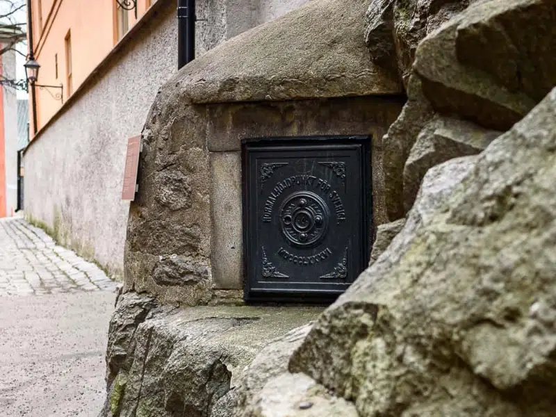
Tucked away on Riddarholmen island, in the heart of Stockholm, lies a seemingly inconspicuous landmark: Normalhöjdpunkten. Marked only by a small metal door set into a stone wall, this modest site holds a remarkable place in Swedish history as the nation’s original zero point for height measurements. Though often overlooked, it played a crucial role in shaping Sweden’s infrastructure, mapping, and scientific advancements.
The Birth of a National Reference Point
In the mid-19th century, Sweden, like many other European nations, recognized the need for a standardized height reference system. Before this, altitude measurements varied across regions, making it difficult to coordinate large-scale infrastructure projects or conduct accurate land surveys.
To address this issue, Swedish scientists and surveyors selected a fixed point on Riddarholmen, chosen for its stable geological conditions and central location in Stockholm. This point was meticulously measured in relation to sea level at Stockholm’s Skeppsholmen tide gauge, establishing an official benchmark for all future height calculations.
At the time, Sweden was also experiencing post-glacial rebound—the slow rise of land following the retreat of Ice Age glaciers. Accurate height measurements were crucial in monitoring these geological changes and understanding their long-term impact on the landscape, particularly in coastal areas where land and water boundaries were shifting over time.
Revolutionizing Infrastructure and Mapping
Once established, Normalhöjdpunkten became the cornerstone of Sweden’s geodetic network, providing a crucial reference for:
- Coastal Surveys and Navigation – Maritime charts and port developments depended on exact elevation measurements to determine safe water depths and shoreline changes.
- Railway and Road Construction – Engineers used the height reference to ensure consistent grading and proper drainage, essential for safe and efficient transport routes.
- Hydrological Studies – Precise elevation data helped in designing canals, dams, and flood management systems, crucial for Sweden’s numerous lakes and rivers.
- Urban Planning and Architecture – Cities and towns relied on altitude measurements to develop building regulations, ensuring proper water runoff and infrastructure stability.

Scientific Contributions
Beyond its engineering applications, Normalhöjdpunkten also contributed to scientific advancements in Sweden. It was a key site for:
- Geodesy (Earth measurement studies) – Scientists used it to track Earth’s shape, gravity variations, and shifts in the Scandinavian landmass.
- Climate and Sea Level Monitoring – Long-term records from Normalhöjdpunkten and related sites provided early data on climate change and rising sea levels.
- International Collaboration – Sweden’s work in geodetic measurements contributed to European efforts in creating a unified height system, eventually influencing global mapping standards.
The Evolution of Height Measurement
As surveying techniques advanced, Sweden transitioned to more precise and modern height reference systems. In the early 21st century, the country adopted RH 2000 (Rikets Höjdsystem 2000), an updated national height system based on modern satellite geodesy and GPS technology.
Despite its age, Normalhöjdpunkten remains historically significant. It symbolizes an era when scientific precision and meticulous measurement were the foundation of national progress. The small, unassuming marker on Riddarholmen is a reminder of Sweden’s pioneering role in engineering, cartography, and Earth sciences.
Normalhöjdpunkten is part of Stockholm scavenger hunt and walking tour!
Embark on an unforgettable journey through the enchanting city of Stockholm with World City Trail. Our interactive walking tour combines the thrill of exploration with the rich history and culture of this beautiful city.
Key Features:
Interactive gameplay: Solve engaging puzzles and challenges as you explore the city.
Hidden gems: Uncover lesser-known spots.
Cultural insights: Learn about the city’s fascinating history.
Flexibility: Explore at your own pace and create your own itinerary.
Family friendly activity and a great way to explore the city!
Further reading on Wikipedia: Stockholm