
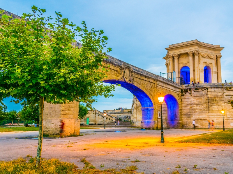
The Aqueduc Saint-Clément is the 18th-century aqueduct that brought spring water into Montpellier, ending at the Promenade du Peyrou, the highest point of the city. Its final stretch, a long double row of stone arches, is so much part of the cityscape that it gave the whole district its name: Les Arceaux, "the little arches". The engineer Henri Pitot took the Roman Pont du Gard as his model.
The Aqueduc Saint-Clément at a glance
- Where: from the Promenade du Peyrou westwards along Boulevard des Arceaux, on the western edge of the historic centre.
- Built: 1753–1765; the first stone was laid on 13 June 1753 and the aqueduct was inaugurated on 7 December 1765.
- By: Henri Pitot, a French hydraulic engineer; the water tower at the Peyrou end is the work of the Montpellier architect Jean-Antoine Giral.
- What it is today: a listed historic monument, no longer in use, with a market, pétanque players and parked cars beneath its arches.
- Time needed: 30–45 minutes to walk the length of the arches from the Peyrou and back.
Three centuries of thirst
Montpellier had looked for a way to bring water from outside the city since the Middle Ages: King Charles VII already urged it to tap the Saint-Clément spring in 1456, and the idea was studied again in 1673. Only in 1751 did the city council decide to build an aqueduct from Saint-Clément-de-Rivière in the north to the Peyrou. Pitot copied the Pont du Gard's principle of large arches carrying smaller ones, which reduced the risk of cracks and leaks.
When the water first arrived, about 25 litres flowed into the Peyrou water tower every second. As the city grew, the aqueduct was extended north to the source of the Lez in 1859, and in 1931 a new underground pipe raised the flow tenfold. The aqueduct was taken out of service in 1983. Parts of it were listed as historic monuments from 1954, and since 2022 the protection covers its entire route.
What to look for
- The two tiers of arches: on the Arceaux section there are 53 large arches, each about eight metres wide, topped by 183 smaller ones, three small arches above every large one.
- The height: at its tallest point the structure rises to more than 20 metres, while the channel on top is only about 1.35 metres wide.
- The wall section at the western end, near the Arcades reservoir, where the small arches sit on a continuous wall instead of on large arches.
- The three big arches at the eastern end: added between 1765 and 1775 to span the first terrace of the Promenade du Peyrou, they replaced Pitot's last four arches.
- The water tower on the Peyrou: an elegant pavilion with columns, where the aqueduct delivered its water to the city's fountains.
Life under the arches
The aqueduct still shapes daily life in Les Arceaux. On Tuesday and Saturday mornings a market of local growers, cheesemakers and bakers sets up at its foot, many of them organic. Under the old plane trees nearby, pétanque players gather much as they would in a village square, and the arches frame the view in almost every direction.
Tips for your visit
- Start at the Promenade du Peyrou: from the terrace you can look down along the arches before walking beside them.
- Late afternoon is pleasant, when the low sun lights up the stone and the boulevard is shaded by the plane trees.
- Come on a market morning if you enjoy local food, but expect crowds and little space for photos.
- The arches stand among roads and parking spaces, so watch for traffic while you take pictures.
Nearby
- Promenade du Peyrou: the royal esplanade with an equestrian statue of Louis XIV and wide views, right at the aqueduct's end.
- Arc de Triomphe (Porte du Peyrou): the 17th-century triumphal gate at the entrance to the Peyrou, a few minutes' walk away.
- Jardin des Plantes: founded in 1593, it is the oldest botanical garden in France.
- Saint-Pierre Cathedral: the Gothic cathedral with its unusual porch on two huge round pillars.
See Montpellier with World City Trail
Our Montpellier scavenger hunt turns the old town into a game you play on your phone. The route takes around 2 hours, with about 36 minutes of walking. You can play in English, German, French, Italian, Spanish and Dutch.
If you prefer a different format, there is also a self-guided walking tour and an outdoor escape game in Montpellier.
Play the Montpellier scavenger hunt →
Take the self-guided walking tour of Montpellier →
Play the outdoor escape game in Montpellier →
Facts checked in October 2026.